

Tjukanov created his North American road map on the same week he posted similarly developed maps of Germany and Finalnd. […]
Tjukanov created his North American road map on the same week he posted similarly developed maps of Germany and Finalnd.
It was the map of his own country that he released first on Wednesday morning, explaining a bit of his process and the program he was using in the accompanying tweet.
‘Few million row snapshot from freshly loaded @openstreetmap planet file showing nothing but roads from the data,’ wrote Tjukanov, who opted to highlight those roads in a royal blue color while once again using a background a simple white.
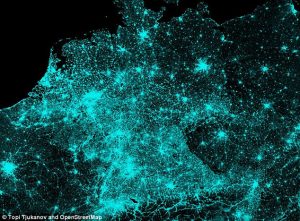
Later that day though he showed some artistic flair when he posted a neon gren-lined road map of Germany on a black background, writing: ‘All #OpenStreetMap roads from Germany (and nothing else). Quite interesting that you can almost see the old East Germany from the data!’
He later wrote on Twitter: ‘Maybe I should post few more of these. Visualising big(ish) data like this shows interesting patterns.’
On Monday, he teased his creations by showing a GIF of Open Street Map as it got to work filling out the roadways and routes out of Tempere, a city in southern Finland.
That would later become part of his larger map showing the southern coast of Scandinavia and sections of Poland, Lithuania, Lativia and Estonia bordering the Baltic Sea.
He did this in order to teach his followers how to make the same amazing maps, writing: ‘Finally writing the tutorial on how to do these. Few pages of text + pics + Python scripts already done.’
Tjukanove then added: ‘Did some testing with these scripts earlier. +10k routes are calculated in just few minutes. GPX parsing and csv merging still a bit slow.’
He had the system figured out two days later however, and the question now if whether or not he will release more.
And he is not afraid to promote the work of others, retweeting one Brooklynite after he posted a map with ‘every street extended to the edge of the borough’ on Wednesday.